User manual
Pixelmast Cloud
A web portal and Android app for your boat: see where she is, watch her instruments, replay every passage, get alarms and an anchor watch, plan a route against the forecast, and follow a regatta live. This manual covers the portal at pixelmast.com/cloud, the race pages at pixelmast.com/race and the Pixelmast Cloud Android app.
Units used everywhere: speeds in knots, distances in nautical miles (metres for short distances), courses and bearings in degrees true. The portal and the app screens are in English; button names in this manual are shown exactly as you will see them, like this.
1. What Pixelmast Cloud is
Pixelmast Cloud collects your boat's position and instrument readings from a Pixelmast device or from your phone, keeps them safe on the server, and shows them on a map you can open from any browser or in the Android app.
| Feature | What it gives you |
|---|---|
| Live map | Every boat you own or that was shared with you, with speed, course and instruments, plus AIS traffic heard by Pixelmast boats. |
| Weather layers | Wind, waves, sea current and rain on the map, with a forecast time bar, and live wind stations ashore. |
| Trips and replays | Every passage is recorded automatically and can be replayed in 2D or 3D with all instruments. Export to GPX or CSV, or share a link. |
| Alarms and zones | Warnings by e-mail for anchor drag, depth, wind, engine, battery, tanks, entering an area and more. Draw no-go and alert zones. |
| Anchor watch | A server-side anchor watch you can arm from the map, from the phone app or from the boat's own device. |
| Weather routing | A route between two points computed from the forecast and your boat's polar. |
| Racing | Set up a regatta, give spectators a live page, and replay the race afterwards in 2D or 3D. |
| Android app | Turns your phone into a boat tracker, with race mode and anchor watch, and shows the portal on board. |
2. Getting started
2.1 Create your account
- Open pixelmast.com/cloud. In the Register card enter your name and surname, your e-mail and a password (at least 6 characters), tick the required confirmation box and press Create account.
- An e-mail with a 6-digit code and a link is sent to you. Type the code on the Check your email page and press Verify, or just tap the link in the e-mail (even on another device: the waiting page signs in by itself). The code and link are valid for 10 minutes.
- Your account is created and you are signed in.
Signing in later works the same way: enter e-mail and password in the Sign in card, then confirm with the link or 6-digit code that is e-mailed to you. If you forget your password press Forgot password?; you get a reset link that is valid for one hour. Changing or resetting your password signs out your other devices.
2.2 Add your boat
- Open Settings in the top bar, then Boats.
- Press + Add boat, type the boat's name and press Create.
- Open the section Boat settings & sharing. The pairing token is there; press Show to reveal it. Keep it private: whoever has it can upload positions as your boat.
2.3 Connect something that sends data
- Can2wifi gateway (Tactic Gateway box). In the device's web page open Setup, find the Cloud Tracks card, tick Upload voyages to pixelmast.com, paste the pairing token and press Save, then Test connection. The box needs a real internet connection, not just Wi-Fi. Details are in the gateway user manual.
- Android app (Pixelmast Cloud on your phone). Install the Android app (section 3) and link it to the boat (section 4). Good for boats without a Pixelmast box, and for regatta fleets.
You can use both. While the box is reporting, the phone's positions for that boat are ignored; when the box goes quiet the phone takes over again.
As soon as the first position arrives the boat appears on the live map. On the Boats page a green dot next to the boat means a device is connected.
2.4 Finding your way around
The top bar of the portal has four tabs: Live (the map), Planner, Editing & alarms and Settings (sub-tabs Account, Boats, Fleets). On the right are the links Race and Sign out. On a phone the side list opens with the button at the bottom-left of the map (Tracks, Route or Alarms, depending on the tab).
3. The Android app: install, sign-in, permissions
3.1 Installing
Pixelmast Cloud is currently distributed through the Google Play testing programme. You receive an invitation by e-mail: open the link on the phone that is signed in to Google Play with the invited e-mail address, accept the invitation (Become a tester) and install Pixelmast Cloud from the Play page that opens. Android 7.0 or newer is required. If you have not been invited yet, ask us (section 13).
3.2 Signing in
The app shows the Pixelmast Cloud portal inside it, so you sign in exactly as on the web (section 2.1). The top of the screen has these buttons: home, Anchor, offline chart, the instruments button, Tracker (it reads REC while tracking is on), back, forward, refresh and full screen. The REC button shows the chosen tracking mode as soon as you pick it. The zoom buttons on the chart follow the day or night colours of the app.
3.3 Permissions
On first start the app explains why it needs your location: it records your boat's track and runs the anchor alarm and race mode even when the app is closed. Your position is sent only to your boat on pixelmast.com. Then Android asks for:
- Location, precise. Required for tracking.
- Location "All the time" (background location). Without it Android stops tracking as soon as the screen is off or the app is in the background. If Android sends you to a settings page, choose Allow all the time.
- Notifications. Required for the always-visible tracking notification (with a Stop button) that Android shows while tracking runs.
4. The Android app: tracking your boat
4.1 Link the app to your boat
- In the app open Settings → Boats and select your boat. The app picks up the boat's token by itself.
- Press Tracker at the top. The first field holds the boat token. If it is empty, paste the pairing token from Boat settings & sharing (section 2.2).
- Press Test Token. A green Connected to boat: … means it works. Error 403 means the token is wrong or blocked.
If no boat is set yet, pressing REC opens the Choose your boat screen. Pick one of the boats of your portal account from the list, or enter a boat token by hand, or press the button to add a boat on the portal. If you are not signed in to the portal, the screen offers a sign-in button instead of the list.
4.2 Start and stop
In the Tracker window press START 24/7 TRACKING. A notification stays in the Android status bar while tracking runs. The window shows Tracking State (ACTIVE or STOPPED), Speed / Course and Queued Points / Upload. If the phone has no signal, positions wait in a queue and are sent later; Clear Telemetry Queue discards them. If the phone restarts, the app resumes tracking by itself.
To stop, press STOP TRACKING in the window or Stop in the notification.
4.3 Normal mode and Race mode
| Mode | What it does | Use it for |
|---|---|---|
| Normal Mode (Default) | One position per minute. Easy on the battery. | Cruising and passages. |
| Race Mode (High Frequency 1 Hz) | One position per second. | Regattas, starts, tactics. Costs battery. |
Race mode belongs to the boat, not just the phone: the same switch is on the portal (section 6) and on a Pixelmast box, and the last command wins. The Tracker window shows Shared State with who switched it and when. After Race Timer Duration (30 min, 1 hour, 2 hours, and longer presets) the app returns to Normal mode by itself. If the boat stays still for 2 hours race mode pauses and resumes when she moves again; after 5 hours stopped it switches off. The app announces these changes aloud.
4.4 Battery tips
- Press Unrestrict under Prevent 6-8 Hour Android Service Stop and allow unrestricted battery use for the app, otherwise Android may stop tracking after some hours.
- Use Race mode only while racing.
- For long passages keep the phone on charge, and do not use a task killer on the app.
Without internet the app keeps recording: in Race mode the buffer holds about 48 hours of one-position-per-second track plus the AIS traffic (track and AIS are stored separately, so heavy AIS traffic never pushes out your own track). Everything uploads automatically, oldest first, when the phone is back online; a long backlog can take an hour or two to drain. Clear Telemetry Queue discards the unsent data.
4.5 Anchor watch in the app
Press Anchor in the top bar. In Maritime Anchor Watch choose the Alarm Radius (Swing Scope) (15, 20, 30, 40, 50, 75 or 100 m) and press DROP ANCHOR; later press WEIGH ANCHOR (it asks Disarm anchor watch?). If the watch alarms the phone speaks aloud and ACKNOWLEDGE ALARM (Mute Siren) silences it. This is the same server-side watch as on the map (section 8), so you can arm on the phone and check from the portal.
4.6 Boat Wi-Fi: instruments and AIS on the phone
If your boat has a Wi-Fi gateway that streams NMEA 0183, connect the phone to the boat's Wi-Fi, open Tracker and switch on Boat NMEA 0183 & AIS Wi-Fi. Choose UDP Broadcast or TCP Client (for TCP also enter TCP IP/Host) and the Wi-Fi Port. The line NMEA Stream: … Sentences … AIS … shows that data is arriving. Open Dashboard opens NMEA 0183 Boat Instruments, with pages Wind Dial, Nav & Depth, Systems, AIS Radar and Custom Gauges. Customize sets units (knots, metres/feet/fathoms), the data source sentences and the dashboard's own shallow-water and high-wind warnings.
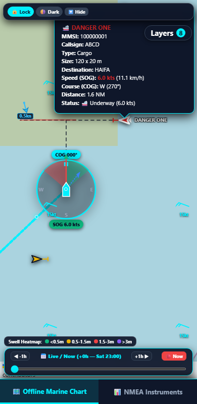
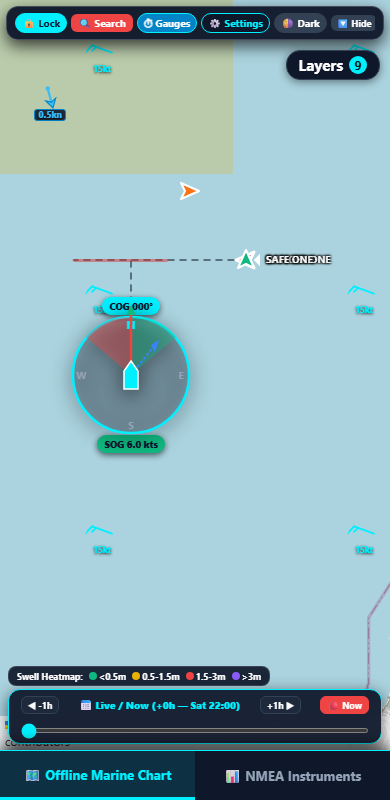
Since app 5.8.8 the phone decodes the full AIS data: each target shows its name (once the ship has sent it, usually within a few minutes), call sign, type, length and beam, destination, speed and course. On the offline chart (section 4.7) names appear next to the targets when you zoom in, and the AIS Radar tab of the Instruments screen lists the nearest 20 targets. Targets on a dangerous crossing course with your boat are drawn red with a red bar on their track, using the same rule as the portal's live map (section 5): the bar is the stretch of the other vessel's course it could occupy while you reach the crossing point, allowing 25% speed error for you and 10% for the target, up to 30 minutes or 6 NM ahead. It is an aid to attention, not a collision-avoidance system.
4.7 No internet: offline chart and offline areas
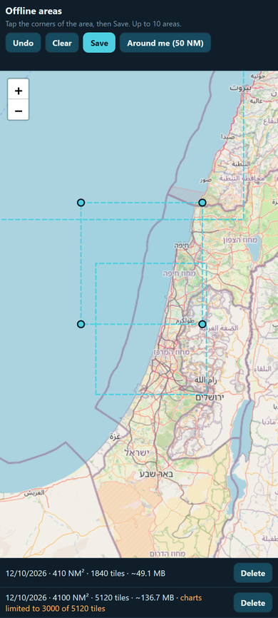
The app keeps charts and weather for offline areas you draw yourself. In Tracker press Offline areas: a plain map opens, tap the corners of the area and press Save (Undo and Clear correct the draft, Around me (50 NM) adds a circle around your position). Areas have no name: the list under the map shows the date, the size in NM², the number of chart tiles and the download size, with Delete per area; up to ten areas. A very large area is not refused: the charts are limited to 3000 tiles (the whole area at the coarse zooms, finer detail as far as that allows) and the weather box to 5°, and the list says so. The areas live only on the phone.
Press Update offline data in Tracker while you still have internet. The app first shows what it will download for every area (chart tiles at zoom 8–12, how many are missing and the size), then fetches the chart tiles, the nautical marks, the depth contours, a 72-hour weather pack from Pixelmast (DWD ICON-EU and ECMWF: wind, gusts, CAPE, waves, currents), the closed zones and the wind stations. Chart tiles are refreshed only when they are missing or older than 30 days; weather, zones and stations are refreshed every time. Clear Offline Cache frees the space and Clear Live Sailing Track erases the track line on the phone.
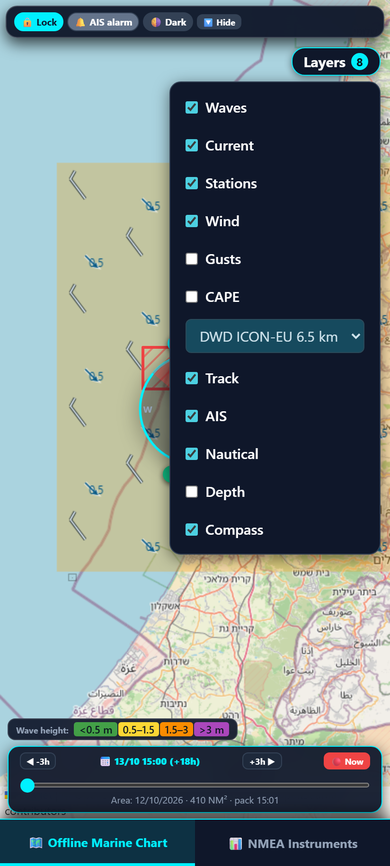
When the phone loses the internet the app switches to the offline chart with your position, track, AIS and the downloaded data. Short drops no longer flip the app back and forth: it waits a minute before going offline and comes back online only after the connection has been stable for two minutes; the map button in the top bar still switches by hand. The offline chart uses the same colours, wind barbs, current arrows and Layers menu as the live map on the portal. The menu holds waves, current, stations, wind, gusts and CAPE (waves, gusts and CAPE show one at a time), the forecast model, and the app's own track, AIS, Nautical (seamarks and depth contours together) and compass rows. The bar at the bottom scrubs the forecast in 3-hour steps for the next three days; Now returns to the current step, and the line under it names the area whose weather is shown and when it was downloaded. Wind stations are real shore and airport observations with their age; a station dims when its reading is older than an hour. A layer with no downloaded data stays empty.
Closed and restricted zones published by Pixelmast Cloud are always drawn; there is no switch for them. A zone you have marked ignore for me on the portal (section 8) is drawn dark green instead of red on the phone too. Instrument settings (units, gauges, the AIS alarm switch) are behind the gear icon at the top of the NMEA Instruments screen.
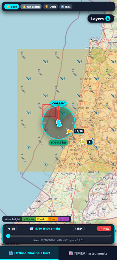
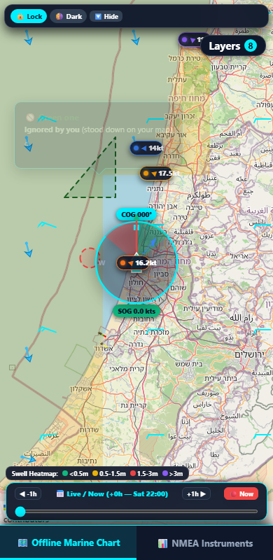
The Go to boat button also controls the orientation of the offline chart. When the chart is not following the boat, a press centres the chart on the boat and starts following. When it is already following, each press switches between North-up (as before) and Heading-up: the chart turns so that the boat's course points up and the boat sits a third of the way up from the bottom; in Heading-up mode the button turns amber with a tilted arrow. Dragging the chart stops following and freezes it at its last rotation; the next press returns to the boat in the same mode. Below 1 knot the last course is kept. The chosen mode is remembered.
4.8 AIS collision alarm
The app can warn you with sound when an AIS target is on a dangerous crossing course (the red targets of section 4.6). The alarm is off by default: switch it on with the AIS alarm button on the offline chart bar or with AIS collision alarm in the Instruments settings. It runs inside the tracking service, so it keeps working with the app in the background and the screen off, as long as tracking is on and the phone is connected to the boat's Wi-Fi.
The alarm, like the AIS display itself, needs an AIS data stream on the boat: an AIS receiver or transponder on the boat's network and any NMEA 0183 Wi-Fi gateway that forwards it to the phone, for example the Pixelmast Can2wifi gateway. Without a gateway the phone sees no AIS and the alarm stays silent.
The sound gets more urgent as the situation develops:
| Stage | When | Sound |
|---|---|---|
| Watch | A dangerous target more than 20 minutes from the crossing and more than 3 NM away | A short beep every 30 seconds |
| Warning | Crossing within 20 minutes, or target closer than 3 NM | A long beep every 8 seconds |
| Alarm | Crossing within 10 minutes, or target closer than 1.5 NM | Loud beep-beep-beep every 3 seconds, vibration, the dangerous vessel and its danger bar flash red on the chart, the AIS alarm button turns red with the target's name, distance and minutes to the crossing, and a notification |
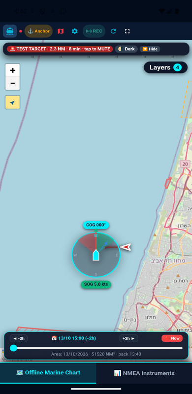
The beeps use the phone's alarm volume, not the media volume. Tap the red AIS alarm button on the chart bar (or Mute on the notification) to silence the current situation. The alarm re-arms by itself when the danger grows significantly: a new vessel becomes dangerous, the stage rises, or the time to the crossing halves. A mute also expires once no target has been dangerous for 5 minutes, so the next encounter is announced again. A stage is entered only after it has held for two seconds and left only after fifteen seconds, so a single noisy AIS position does not trigger it.
The alarm is an aid to attention based on straight-line courses and the targets' own AIS reports. Keep a proper lookout; it says nothing about head-on or overtaking situations.
4.9 Boats on the chart
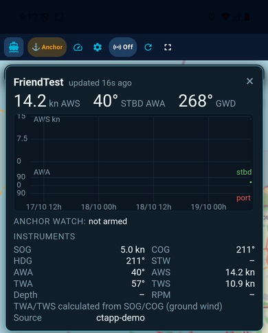
With internet the app chart can show your own boats and the boats shared with you (section 11.3). Open Layers and use the Boats chip; it is on by default and works online only (the offline chart does not show it). A boat under way is drawn as a hull pointing along her course, a stopped boat as a dot, and a small wind barb is added when the boat reports wind. If you are not signed in to the portal the app shows the note Sign in to see your boats.
Tap a boat to open its status window: the live readouts, the wind graph, the instruments and the anchor-watch state. The window is read-only, you cannot change anything on the boat from it. The Android Back button closes the window.
If a boat uses the same token as this phone and has a Can2wifi gateway sending data, the boat is drawn from the gateway data. While the phone is on the boat's Wi-Fi and takes its position from the boat, the boat is not drawn a second time - your own boat marker already shows it.
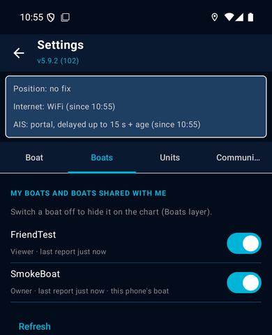
The list of boats is in Settings → Boats: your boats and the boats shared with you, each with your role (owner or viewer) and the time of its last report, and a switch to show or hide the boat on the chart. Refresh reloads the list.
4.10 The online chart: layers, stations, speed
- The chart loads faster with internet: map tiles that were saved earlier are shown first, and areas you have seen once appear instantly.
- The Nautical chip now shows the seamarks and the depth contours together. There is no separate Depth chip any more.
- Tap a wind station. Online, a panel opens with the station data and a 24-hour wind graph. Offline, a short text popup shows the last reading.
- The status of the data sources (position source, internet, AIS source) is now a status bar at the top of Settings instead of the top bar of the chart.
4.11 Background update of offline areas
The app keeps your offline areas (section 4.7) up to date by itself, while the app is open or tracking is on. It checks every 30 minutes and updates what is due: the weather when it is more than 72 hours old, the map tiles when they are more than 30 days old. It also updates when the internet comes back. Switch it on or off with Background update in Settings. Updates also run over mobile data (4G). Abroad, on roaming, they run only when Use roaming data is on there, so you do not pay roaming charges by surprise.
5. The map and its layers
Open the Live tab. The list on the side shows My boats and Shared with me. Each boat has a checkbox (show or hide), a colour, a name and its state: live (reported within the last 30 minutes), last with the time, or no data. Click a boat name to zoom to it. Under each boat are its trips: tick a trip to draw it, Replay opens the replay.
On the map a boat under way shows as a hull pointing along her course, an anchored boat with the watch armed as an anchor symbol, and a boat that has been silent as a grey dot. A small orange wind barb shows the wind from the boat's own instruments. Click a boat to open its window (section 6).
5.1 Layers
The chips in the top bar switch layers on and off. Your choices are remembered.
| Chip | Shows |
|---|---|
| AIS | Vessels heard by the AIS receivers of Pixelmast boats (not a worldwide feed). Moving vessels are arrows, slow ones dots. Hover for name, speed and course; click to draw a 12-hour trail. On by default. Targets on a dangerous crossing course with your own boat are drawn red with a red bar along their course (the stretch they could occupy while you reach the crossing point); grey bars mark crossings that are not dangerous. The Danger chip in the top bar switches the bars on and off. |
| Waves | Forecast wave height, coloured: under 0.5 m, 0.5-1.5, 1.5-3, over 3 m. |
| Current | Forecast sea-surface current as arrows, with speed in knots when zoomed in. A coarse model: treat it as a guide. |
| Stations | Live wind from shore stations and airports (Israel Meteorological Service, Cyprus Department of Meteorology, METAR/TAF airports). Click a station for wind, gusts, direction, temperature and a 24-hour graph; airports also show the raw METAR/TAF. |
| Wind | Forecast wind as wind barbs. |
| Rain | Rain radar where available (Israel, Cyprus, Greece, Turkey) and a satellite estimate elsewhere. A bar at the bottom-left has a play button and a slider that steps back through the last 24 hours in 10-minute steps. |
| 3D | 3D view (section 5.4). |
Rain works alone: switching it on switches off Wind, Waves and Current, and the other way round.
Forecast coverage is the Mediterranean. Outside it the weather layers stay empty.
5.2 The forecast bar
With Waves, Current or Wind on, a time bar appears at the bottom of the map. Click an hour to see the forecast for that time (click it again to return to now), or press the play button to run the forecast forward, one hour per second. The model selector next to it offers DWD ICON-EU 6.5 km (about 5 days ahead, the default) and ECMWF IFS 0.25° (about 6 days ahead). The forecast refreshes by itself several times a day.
5.3 Measuring and depth
- Ruler (the button below the zoom buttons): click points on the map, or tap boats, AIS targets and stations. Each leg shows distance in nautical miles and the bearing; with three or more points you also get the total. Press Esc or the button again to finish.
- Depth contours (next button): shows depth contours. With it on, right-click (or long-press on a phone) anywhere to read the sea-bed depth. It is a modelled value, not a sounding.
- Go to boat: centres the map on your boat.
5.4 3D view
Press 3D for a three-dimensional picture of your ticked boats, the coast, harbours, relief and the AIS ships around you, shown a few seconds behind real time. Camera buttons: Follow, Helicopter, Free; click a name tag to follow that boat. The wind rose shows wind and gusts. Press 2D to go back. If your browser cannot do 3D the button is simply not shown.
6. The boat window and live instruments
Click a boat on the map. Its window shows:
- the big readouts: apparent wind speed (kn AWS), apparent wind angle with PORT or STBD, and the wind direction over the ground (GWD);
- a two-day graph of wind speed and angle; click it to enlarge and drag across it to zoom;
- the Instruments grid: SOG, COG, HDG, STW, AWA, AWS, TWA, TWS, depth, RPM, battery (volts and %), fuel and water tanks (%), total distance on the server and the data source. Only what your boat sends is shown; missing values show a dash. If true wind is not on the bus it is calculated from speed and course over the ground and marked as such;
- the Anchor watch line and its controls (section 8) and the Race mode button.
Values turn grey when the last report is older than 5 minutes. Messages such as no GPS fix mean the instruments are live but the position on the map is the last trusted one.
Race mode button: Race mode on / Race mode off switches the boat to one position per second. It turns red while the command is waiting for the boat to confirm and green once confirmed. The text next to it says when it was requested and accepted. Viewers cannot press it. The boat switches race mode on by itself one hour before a race it is entered in, and off after 5 hours stopped.
7. Trips and replays
7.1 Trips
Trips are recorded automatically. A trip ends when the boat has been stopped (under 1 knot) or silent for about 5 hours. Open Settings → Boats for the full list: start time, duration, distance and name. Every trip has Replay, GPX and CSV. Owners and co-owners can also:
- rename a trip (type the name, press OK);
- Combine↓: merge a trip with the next one (for a passage that was split by mistake);
- Keep: protect a trip from clean-up (up to 10 kept trips); Delete removes it;
- Link: create a public link (see 7.3); Kill link cancels it;
- Share / Unshare with another account by e-mail (read-only).
Trips others share with you are under the tab Shared trips.
7.2 The replay
The replay page draws the track and plays the passage back with all instruments exactly as recorded. The sidebar has Trip summary (duration, time underway, sailing and engine time, distance, average speed, max SOG and TWS, fuel used) and Instruments. The bottom bar has:
- play, a speed selector (from 1× to 2400×, default 60×) and a time slider;
- trails: Trails 30 min, Trails full or Trails off;
- tick boxes Follow boat, AIS (other vessels as they were then, kept for about 3 months), Boat data, Barbs (forecast wind) and Boat wind (the boat's measured wind);
- 3D / 2D: the same replay as a 3D scene (cameras Follow, Helicopter, Free).
7.3 Sharing a trip
Press Link and a public address is created and copied. Anyone who has the link can open the replay without an account; it shows the trip only, not your other data. Press Kill link to cancel it at any time; a new Link creates a new address.
8. Alarms, zones and anchor watch
8.1 Alarms
Open Editing & alarms → Alarms and press + New alarm. The wizard asks one question at a time: which boat, what to warn about, the threshold, a name, and whether the boat's other users get it too.
| Category | Alarms |
|---|---|
| Navigation | Anchor dragging, Shallow water, Arriving somewhere, Enter to area, Cross line, Route corridor (stay near a saved route), Passing a buoy (left, right or either side). |
| Weather | High wind (true wind above a speed). |
| Boat | Engine over-revving, Engine temperature, Battery low, Tank running low (fuel or water), She starts moving, She stops. |
An alarm fires when the condition is crossed, not for something that was already true when you created it, and then waits 10 minutes before it can fire again. Alarms arrive by e-mail with the position and a map link. Because the boat's device uploads every couple of minutes, an alert can arrive about 2-3 minutes after the event. A private alarm e-mails you; a shared alarm e-mails the owner and co-owners. Viewers do not receive alarm e-mails.
8.2 Zones
In Editing & alarms → Map editing press + New zone. Choose Keep my routing out of it (and warn me) for a no-go circle, area or line that the Planner avoids, or Just tell me about it for an advisory circle or area. Zones are private to you. You can offer a zone to every user (Offer it to every user as a global zone?); it is reviewed and, once approved, cannot be edited. For a published zone you can tick alert me, avoid in routing or ignore for me.
On a zone published by Pixelmast you can tick ignore for me: it stays on your maps, drawn dark green instead of red (also in the Android app), and your routing no longer avoids it. Alerts you opted into are not affected.
8.3 Anchor watch
- Click your boat on the map to open its window.
- Under Anchor watch choose 20 m, 30 m, 50 m or Custom (20-300 m).
- Press Arm. A dashed circle and a 12-hour tail are drawn on the map. Choosing another distance while armed re-arms at once.
Disarm asks for confirmation and stops the watch for everyone with access to the boat. The watch can be armed from the map, the phone app or the boat's own device; the last command wins.
| Alert | Meaning |
|---|---|
| possible drag | The boat left the watched circle. |
| lost contact | The armed boat stopped reporting. A dead link is treated as a reason to warn. |
| no GPS fix | Armed, but no reliable GPS position. |
While an alarm is open the button Ack appears. It acknowledges the notification only; it does not make the cause go away. The boat must be connected to the internet for the watch to work. E-mails go to the owner and co-owners when the state changes (drag, moved further, back inside, contact lost and restored).
9. Weather routing (Planner)
Open the Planner tab. Only boats you own or co-own are offered.
- Under Boat & polar choose the boat and its polar. With no polar the Planner uses a generic cruiser (add your polar under Boats, section 11).
- Under Route press Draw route and tap points on the map: two points are enough, and the Planner finds a path that avoids land and no-go zones; with more points it follows your line. Or load a GPX, KML, KMZ or CSV file. Clear, Save route and Delete saved manage your routes.
- Under Limits choose whether the engine may be used when sailing would be slower, and the wave height from which the boat slows down.
- Under Departure set the time, or tick find best departure to compare the next 24 hours.
- Press Compute route.
The result shows the ETA, distance, hours and miles beating, reaching, running and under engine, and the strongest wind and waves. Sailing legs are green and motoring legs orange; tick marks show time, wind, angle and boat speed. Replay plays the predicted passage, GPX exports it. The status line shows how old the forecast is. A route is a one-time calculation: it is not recomputed when new forecasts arrive. You can also upload your own GRIB weather file to be used instead of the forecast for 24 hours.
10. Racing
10.1 For the organiser
Press Race in the top bar, then + New race. The wizard has seven steps: Kind (Inshore buoy racing or Offshore point-to-point), Basics (name, date, scoring), Points, Classes, Roster, Review, Share.
- Points: click the committee boat end and then the pin to place the start line, then add buoys or points in rounding order, each with Pass on left (port), Pass on right (starboard) or Arrival (come within a radius), and a finish line. Use Repeat as laps for laps. Coordinates can be typed. Right-click an AIS target to use it as a point, for example the committee boat.
- Classes: each class has its own scoring (Time on Time (TCC), Time on Distance (GPH) or Elapsed time) and planned gun time.
- Roster: add boats by name and sail number, or Choose CSV. Then Attach boat links each row to a boat that uploads to Cloud (a Pixelmast box or the phone app) or to an AIS target. Skippers do not add themselves; the organiser builds the list.
- Share: copy the spectator link and send it to everyone.
On the race page the organiser runs the start: Start sequence (with sound), Gun now, Postpone, General recall, End class and End race, and sees Standings. The Links section has Copy spectator link, replay links for each finished class (2D and 3D), a sponsor banner, Results CSV and Revoke spectator link. A boat that is entered in a race sees it under Races I'm in, and its race mode switches on automatically one hour before.
10.2 For spectators
The spectator link opens a live page, no account needed. Boats are arrows along their course over ground, coloured by class, with 20-minute tails; a boat that has not reported for 5 minutes is greyed. Chips at the top:
| Chip | Shows |
|---|---|
| Distances | Gaps between boats and the distance to go for each (on by default); a red start zone in the last minute before the gun. |
| Boat data | Next to each boat name: SOG, COG, STW, HDG, TWS, TWD, AWS, AWA and depth, whatever that boat sends, and how old the data is. |
| Wind, AIS, Stations | Forecast wind, nearby vessels and wind stations. |
| 3D | The race as a live 3D scene with coast, terrain and ships. |
The side panel has the start countdown, one tab per class and the standings: rank, boat and corrected time, with status (racing, finished, dnf, dns) and flags such as early start or a missed mark. Results are provisional until the organiser ends the class. After the race the organiser sends the replay link: the race replays in 2D or 3D with Boat distances, Boat data and a boat-details panel (☰). Your own chip choices are remembered.
11. Account, sharing and privacy
11.1 Settings
Settings → Account: change name, e-mail (a code is sent to the new address) or password; choose Dark or Light and your time zone (Auto (browser time) by default).
11.2 Boat settings
Under Boat settings & sharing: the pairing token; own MMSI (your own AIS transponder is then hidden from the map and replays); handicap TCC and GPH for racing; Performance & routing limits (max wind, engine speed, Max speed; the last also rejects impossible GPS jumps so they do not spoil tracks and distances); and Polars (upload a .pol, .txt or .csv polar table with Add polar; up to 10).
11.3 Sharing a boat
Enter the colleague's e-mail, choose as viewer or as co-owner and press Share boat. If they have no account they get an invitation e-mail valid for three days. Under People on this boat you can change roles or Remove someone; unused invitations can be withdrawn.
| Role | Can |
|---|---|
| Owner | Everything a co-owner can, and is the only one who can delete the boat. |
| Co-owner | See live data and tracks; manage trips, boat settings, polars, the token, alarms and anchor watch, race mode; invite and remove people. |
| Viewer | See live data and past tracks and create own alarms. Cannot change the boat or its data or press race mode / anchor watch. |
A viewer can leave a shared boat with Leave boat. Fleets lets several boat owners group their boats (invitations are accepted per boat) and open a combined replay of a time window.
11.4 Who sees what
- Your boats are visible only to you and the people you share them with.
- A trip link (7.3) and a race spectator link (10.2) can be opened by anyone who holds the address; cancel them with Kill link or Revoke spectator link.
- AIS targets on the map are pooled from the receivers of Pixelmast boats, so other users' AIS data can show up for you and yours for them.
- Your phone position goes only to your boat on pixelmast.com. See the privacy policy, including how to delete your data.
12. Troubleshooting and FAQ
| Problem | What to check |
|---|---|
| The boat never appears on the map. | Is the token pasted correctly and uploading switched on? Does the device have real internet, not only Wi-Fi? On a phone, did Test Token say Connected and is tracking ACTIVE? |
| The boat shows as old or grey. | It stopped reporting. Power, GPS, internet and (on a phone) background-location permission and battery restrictions. |
| Phone tracking stops when the screen is off. | Location must be Allow all the time, battery use Unrestricted (section 4.4), notifications allowed. |
| The phone's positions are ignored. | A Pixelmast box is reporting for the same boat; the phone takes over when it is quiet. |
| Anchor watch will not arm. | The boat must be paired and have reported a position. |
| An alarm came late. | The device uploads every couple of minutes, so allow 2-3 minutes. |
| No sign-in or confirmation e-mail. | Check spam. The code and link are valid for 10 minutes; start again if they expired. |
| I cannot see a boat a friend shared. | They must invite the e-mail address you registered with; accept the invitation after signing in. It then appears under Shared with me. |
| Weather layers are empty. | Coverage is the Mediterranean, and forecasts are refreshed on a schedule. |
| The 3D button is missing. | The browser or phone does not support 3D graphics. |
13. Contact
Questions, invitations to the Android test and suggestions: admin@pixelmast.com.